Economic opportunity needs to be part of resilient communities
May 27, 2020
A new investigation and proposal for community transformation in Pomona, California highlights the need to integrate economic opportunity into community resiliency plans. Students in the Graduate Capstone Studio in the Department of Landscape Architecture at California State Polytechnic University, Pomona, conducted a nine-month study in support of Pomona ACTS – a consortium of community-based organizations, institutions and the City of Pomona, charged with transforming a 5.0 square-mile project area in the heart of the city. Pomona ACTS is in the process of pursuing Transformative Climate Community funding from California’s Strategic Growth Council to enhance community resiliency in the face of climate change. The studio team’s full report is available online.
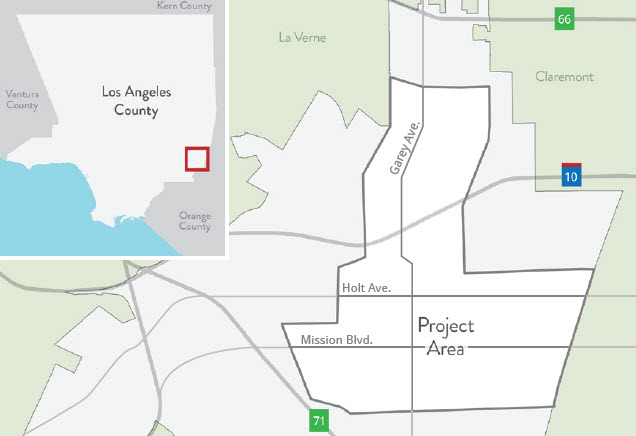
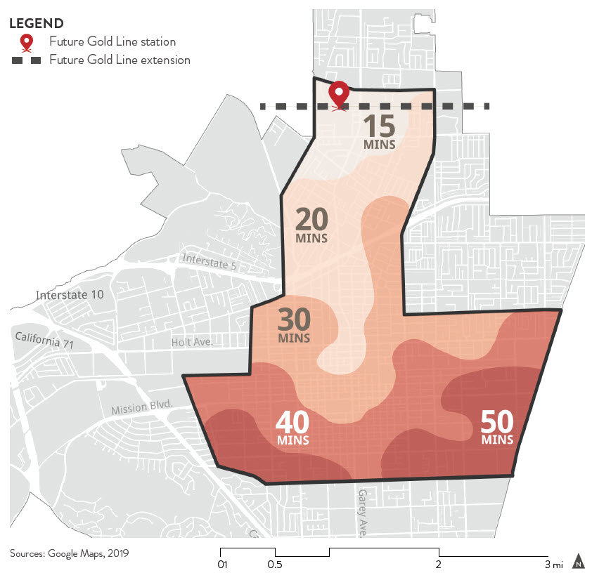
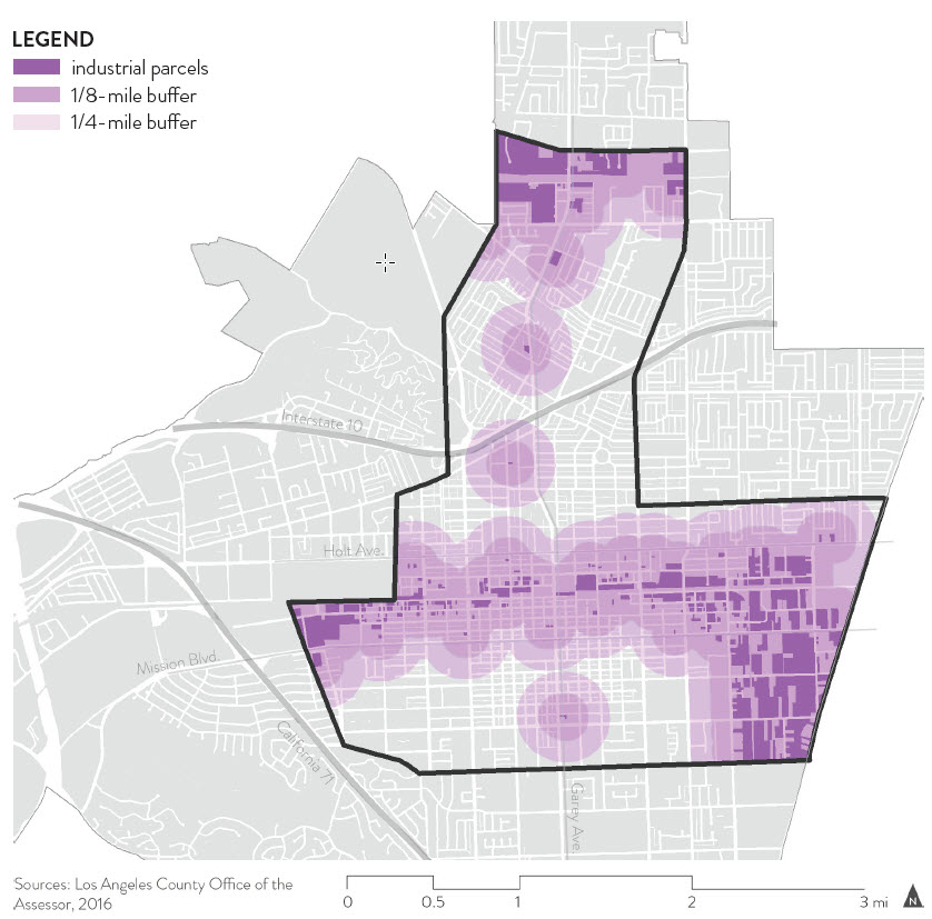
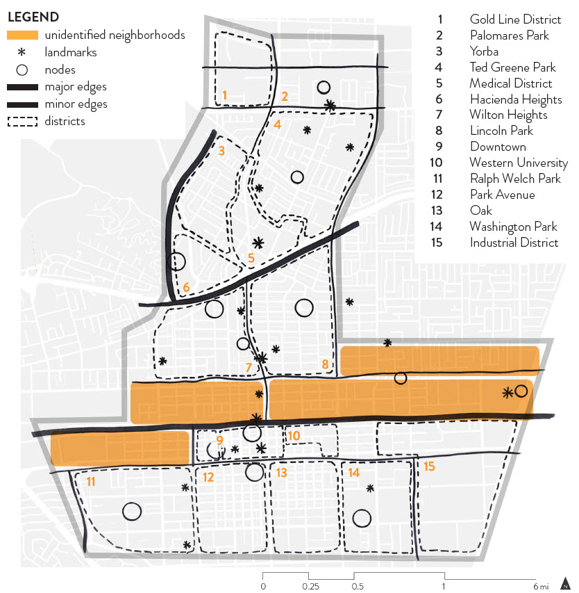
The four-person team, working under the advisement of studio faculty, Dr. Kyle D. Brown, ASLA and Tori Kjer, PLA, examined existing issues and opportunities in the project area, which extends from the site of the future Metro Gold Line Station in the North, to Downtown Pomona in the south, and includes much of the East-West Holt Avenue and Mission Boulevard corridors that transects the heart of the city. Their analysis revealed a number of unique assets, including strong community involvement, the presence of multiple transit lines that offer regional connections, and underutilized properties. At the same time, the study area is challenged by poor local transit connections, significant pollution burdens and economic challenges for residents, and poor pedestrian and bicycle infrastructure, as well as a lack of employment opportunities. These challenges are exacerbated by modeling data that suggests extreme heat events will increase significantly during this century due to climate change. Increased extreme heat translates to greater energy demand and expense for cooling, adverse impacts on the health of vulnerable populations, and decreased air quality during heat waves.
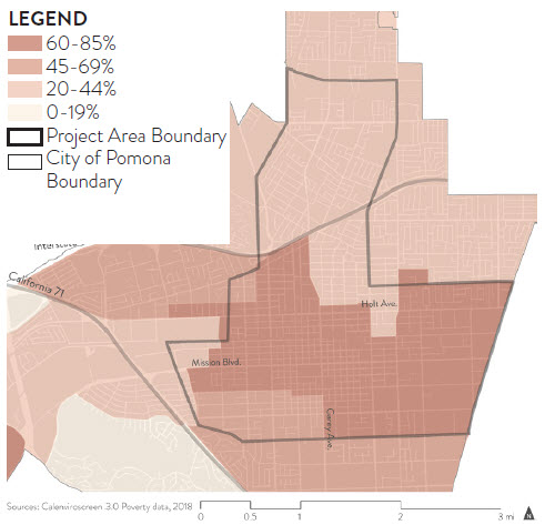
Perhaps most notably, their analysis revealed challenges associated with the east-west rail corridor that bisects the city, and the adjacent property, particularly along the northern edge of the tracks. These neighborhoods reflect a mixture of older industrial uses built in proximity to the rail line decades ago, disinvestment that has occurred along the Holt Avenue corridor as this once vibrant commercial strip has suffered due to freeway and commercial construction in nearby communities, and a variety of housing, ranging from older single-family bungalows to high-density residential communities. These neighborhoods tend to be the source of local pollution due to older, poorly-regulated industrial uses, as as well as road and rail traffic. The team also noted they lacked identity, or resources that support community-building, such as spaces for community gathering, walkable streets, or landmarks that provided distinct placemaking. One advantage these neighborhoods did offer, is Federally-designated Opportunity Zones, where individuals receive tax incentives for investing in businesses and property.
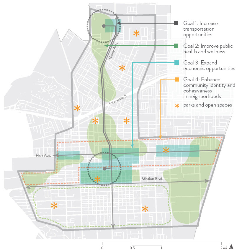
In response to the issues and opportunities identified, the team proposed four goals to guide the their work 1) Increased transportation opportunities, 2) improved public health and wellness, 3) enhanced community identity, and 4) expanded economic opportunity. This fourth goal was particularly noteworthy, in its recognition of the role economic activity plays in resiliency. Much of the focus in resilient urban design focuses on multi-modal transit-oriented opportunities, the provision of open space, and green infrastructure. However the need to consider living-wage earning opportunities for residents, and growth opportunities for property owners is also important. The groups effort considered the balanced integration of economic opportunity with environmental and social considerations. This was particularly evident in the case study designs they offered for specific neighborhoods within the project area.
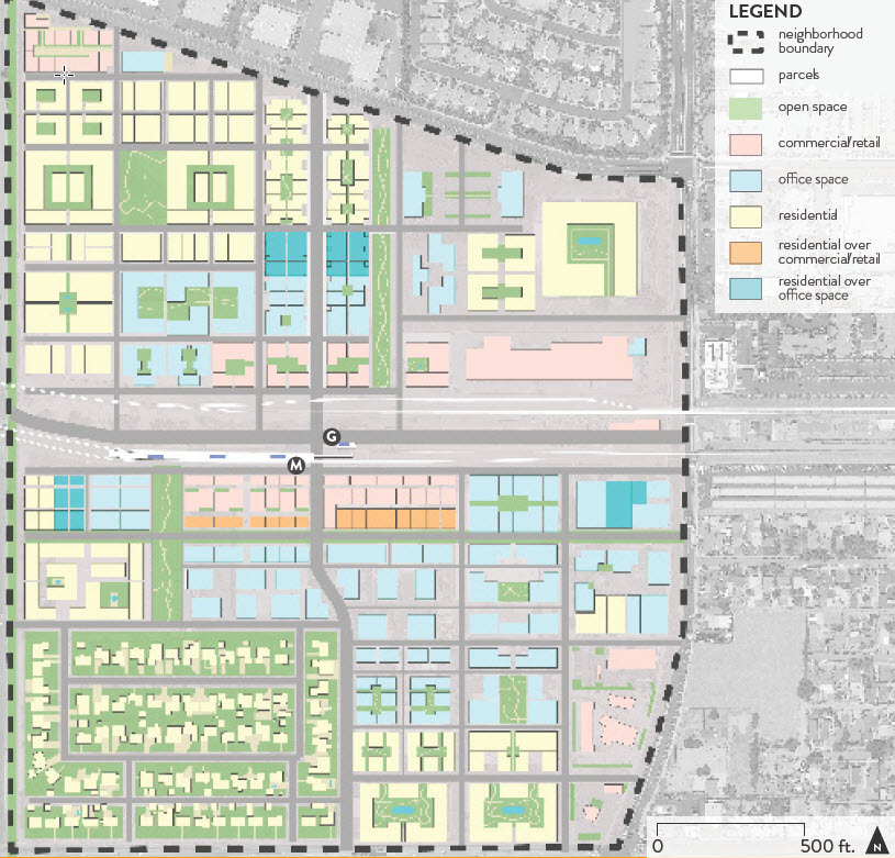
Morgen Ruby examined the potential for regeneration related to the arrival of the Metro Gold Line state in north Pomona in 2025. While this area is home to an existing Metrolink station, the land use has not transitioned from its historic role as a center for light industrial activity. Recognizing that this area presents a major opportunity for economic transformation, Ruby proposed a transit-oriented community that preserved a small number of existing industrial buildings for adaptive reuse as commercial, office and residential spaces. Her concept concentrated community life around the Metrolink/Gold Line stations, featuring a ring of predominantly commercial activity at the core, followed by a ring of office/residential use, and then transitioning to predominantly residential uses. Her proposal leverages the proximity of Casa Colina Hospital and Pomona Valley Hospital and Medical Center to offer a unique opportunity to strengthen Pomona’s health care sector, while also connecting the city to other communities in the San Gabriel and Inland Valleys.
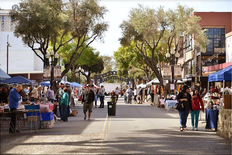
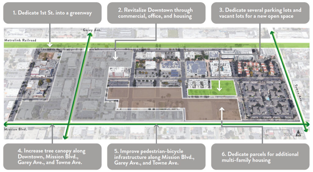
Sancho Cagulada studied development options for the Western University area, including significant portions of Downtown Pomona. Significant portions of this area are dominated by city-owned surface parking lots, many of which are rented by the rapidly-growing healthcare university. while bustling with activity during days the University is in session, activity drops off markedly on evenings and weekends. Cagulada’s proposal argues that the city is better-served by increased density in the downtown area, proposing additional housing, along with streetscape, pedestrian and open space improvements. Additional residential living, in proximity to the Downtown Metrolink transit station, would increase the vibrancy of commercial activity along 2nd street and in other parts of the downtown. In addition, the team proposed a local rapid transit system to provide quick service between downtown and the Metro Gold Line Station detailed in Ruby’s design. This critical link greatly expands the transit opportunities for downtown residents, as well as regional commuters as they transfer between two Metrolink Lines and the Gold Line.
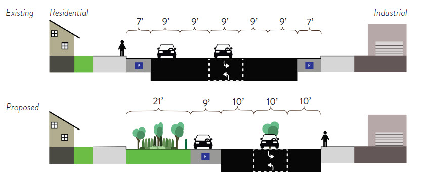
Laurel Skinner examined the potential within a dense, working-class residential portion of the project area, surrounding Washington Park, the largest public park in south Pomona. Skinner noted that the park was a critical gathering space for the community, yet it lacked many desirable amenities and poor pedestrian and bicycle connections for nearby residents. In addition, the neighborhood featured an abrupt transition between nearby heavy industrial zones and residential uses, as well as a lack of access to health food options. Skinner’s solution centered upon expanding local food options, as well as the development of a transit hub at the park, where local residents would walk or bike to access mass transit, car-share or other transportation resources, strengthening their connections to regional economic opportunities. She strengthened pedestrian connection through a series of road-diets and pedestrian/bicycle enhancements along adjacent roadways, and proposed a bold strategy to protect homes from nearby industrial uses by reducing roadway widths to support additional green space and planting. By examining opportunities for living and working spaces to coexist, Skinner simultaneously advances the goals of expanding economic opportunities while improving health and wellness.
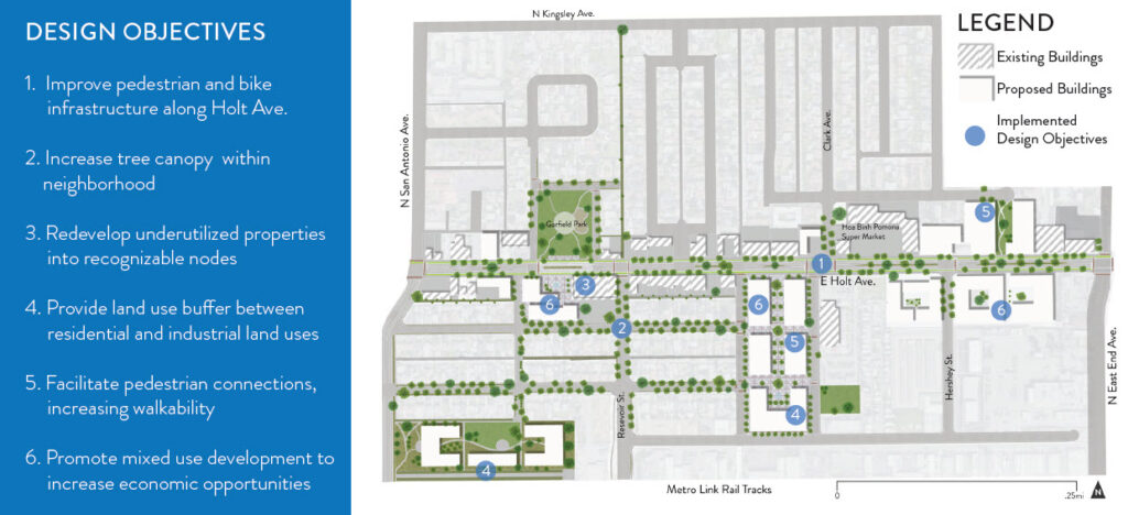
Brian Neshek’s work on re-imagining East Holt Avenue most directly addresses the goal of expanding economic opportunity. Located within the Federal Opportunity Zone areas north of railroad tracks, his neighborhood is characterized by a highly-travelled and pedestrian unfriendly Holt Avenue, where business activity has declined in recent activity. Many older industrial operations, outdoor automotive repair shops, and underutilized properties dominate the neighborhood. Neshek proposed innovative reuse of older, dilapidated industrial and commercial properties, to increase housing and employment opportunities in the neighborhood. The proposal included a redesign of Holt Avenue to prioritize pedestrian and bicycle activity, arguing that such street life would enhance economic opportunity and restore vitality to this historic corridor. Two nodes of activity are proposed: Historic Garfield Park, and “The Collection” a commercial/employment center on the site of underutilized industrial operations. These sites offer the opportunity to nurture microenterprise emerging from community residents, as well as outside investors.
Each of these solutions prioritizes housing options, including affordable housing, in addition to economic opportunities, recognizing that increased density is critical to economic opportunity. In response to concerns about gentrification, the proposals focus on regeneration of older (often polluting) industrial sites, surface parking, and infill housing to increase density while avoiding displacement of existing communities. While this approach is not a panacea for rising housing costs, it offers promise when combined with affordable housing policies and other investments in public infrastructure that support diverse, working-class communities.