Current Green City Studio Projects
Each year, the Master of Landscape Architecture candidates at California State Polytechnic University, Pomona, (Cal Poly Pomona University) partner with communities as part of the Green City Studio – the students’ culminating experience for their degree.
In 2023-24, we are working with five different community partners on projects in Baldwin Park, Huron, Maywood, Mono Lake and Pomona, California. You can view past project reports on our publications page.
If you would like to learn more about the Master of Landscape Architecture Program, visit the department web site, or contact the faculty of the Green City Studio.
City of Baldwin Park, CA
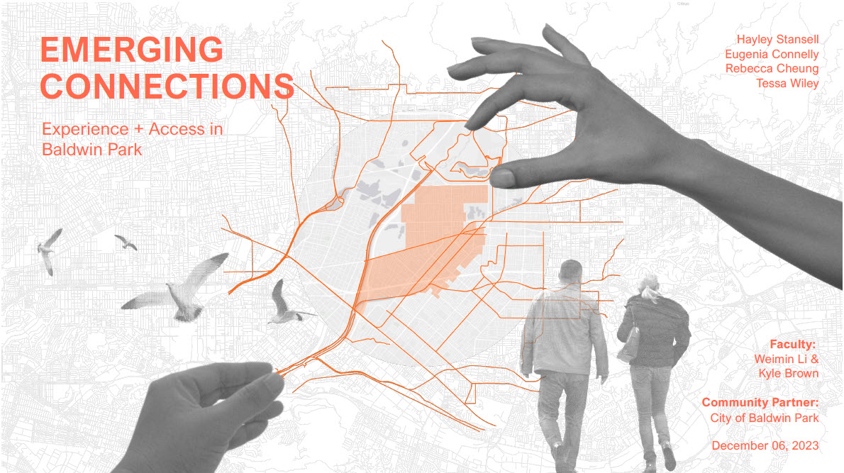
Emerging Connections: Experience + Access in Baldwin Park, California
Rebecca Cheung, Eugenia Connelly, Hayley Stansell & Tessa Wiley
Baldwin Park is a city of approximately 72,000 residents located in the eastern portion of Los Angeles County, California, approximately 15 miles east of downtown Los Angeles. Served by a Pacific Electric Railway (Red Car Line) beginning in the early 20th century, the downtown grew around a street grid within walking distance of this transit line. As the electric trolley was removed in the 1950s, automobiles began to dominate the landscape, changing the community from predominantly walkable to auto-dependent. Today, the community is largely built-out, presenting a number of challenges common to Southern California communities, including a lack of park space, poor pedestrian and bicycle connections, and pollution burdens associated with nearby freeways and industrial activities. At the same time, the city has a number of assets that present opportunities, including a downtown transit center served by Metrolink, a recently adopted Downtown Specific Plan that guides new development and promotes walkability, connections to regional trails systems via the Walnut Creek Wash and the San Gabriel River, and the new Susan Rubio Zocalo Park and Civic Center Plaza, a 3-acre public space in downtown currently under construction, which is the first new park in the city in decades.
The city is interested in leveraging this new public space, the guidance of the Downtown specific plan, and other recent planning efforts into a city-wide vision to guide its efforts toward building livable community, climate resilience, sustainability, and improved quality of life. They seek multifunctional design concepts that strengthen community identity, provide connections between neighborhoods and downtown assets, integrates regional opportunities, and overcomes the challenges with limited green space, active transportation, and other environmental and social factors impacting quality of life in Baldwin Park.
City of Huron, CA
Huron, California: Where the Arroyo Ends
Antonio Olea, Connor Rudmann, Francisco Salas-Tamayo, Andy Sett & Alfredo Zuniga.
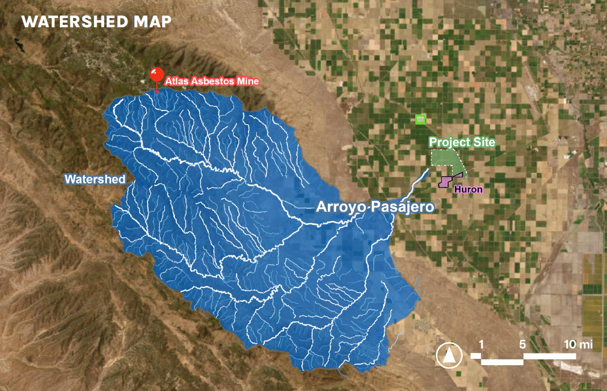
Huron is a small agricultural town in Fresno County, at the heart of the San Joaquin Valley and the State of California. The city covers an area of appropriately 1.6 square miles. As of 2020, Huron has a population of 6,206 (Census 2020) with a median age of 28 and a median household income of $31,429. More than half of its population is foreign-born. Huron is also known to have the highest Hispanic or Latino population (95.65%) in the United States. During the harvest season, the town’s population often rises to 15,000 with the influx of migrant farm workers. Like many disadvantaged communities in the central valley, Huron faces serious environmental challenges, including but not limited to extreme heat, heavy air pollution, severe drought, and groundwater depletion, that further damage public health and other quality of life of its residents, who are generally low-income, living in extreme park poverty, and in lack of resources to fight environmental and social injustice.
To address these critical challenges, Rey Leon, the Mayor of Huron, through the LEAP (Latino Equity, advocacy, and Policy) Institute, has been leading Huron the Beautiful, a conservation, outdoor recreation, and environmental learning project, to envision a better future for the city and its residents. On May 18th, 2023, the National Park Service (NPS), Rivers, Trails, and Conservation Assistance selected the project to receive technical assistance during the RTCA award cycle from June 1st, 2023 – May 31, 2024.
The Huron the Beautiful project aims to improve the environmental amenities of the city and the quality of life of its residents by transforming a large federally owned land parcel (over 1,500 acres) along the California Aqueduct into a local and regional park offering creative and practical solutions. The site is approximately three-quarters a mile north of the city boundary. The Bureau of Reclamation currently manages the parcel, regularly removing and cleaning contaminating sediment from the upper streams of Los Gatos Creek, Jacalitos Creek, and Zapato Chino Creek to prevent negative impact on the aqueduct water. The project also seeks to expand the value and impact of the revitalized site by strengthening its connectivity to the larger ecosystem and recreational network to benefit a larger underserved population in the central valley.
As one of the major project partners, the CPPMLA master project studio will collaborate with the LEAP, NPS RTCA program, and other academic and community partners to provide expertise and technical support related to but not limited to background research, advanced planning & design methods, decision-supportive data, information & technologies, development of planning visions & design proposals, and impact assessments. Potential project deliverables include a regional recreation/trail network and creative park design concepts supported by background research, cross-scale landscape analyses, and impact assessment.
City of Maywood, CA
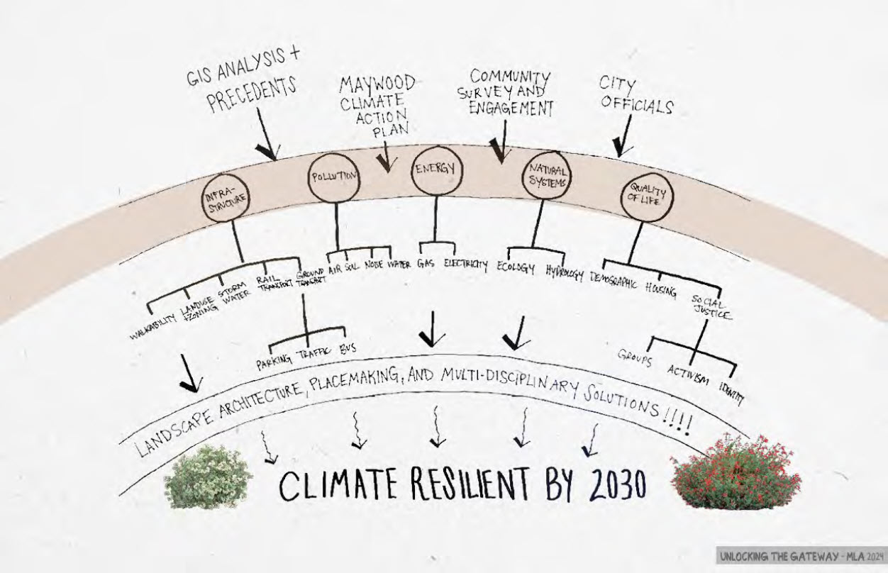
Unlocking the Gateway: A Resilient Future for Maywood, California
Nathan Peterson, Todd Siefke, Petronella Sovella & Soozy Zerbe
Maywood is a small Gateway City in Los Angeles County, with a population of approximately 25,000 residents, 97% of whom identify as Hispanic or Latino. Located along the Los Angeles River, 6 miles southeast of downtown Los Angeles, the City was incorporated in 1924, providing nearby housing for working families.
The City is working to create a healthy, safe, and environmentally responsible community by developing a Climate Action, Adaptation, and Resilience Plan (CAARP). The CAARP will provide a roadmap to accelerate greenhouse gas (GHG) emissions reductions and build the capacity of the City and residents to prepare for and address the impacts of climate change. This effort is in conjunction with the Gateway Cities Council of Governments, that has established a climate action planning framework to support action planning in local communities. To date, the City has completed a 2010 baseline GHG inventory, which found that over half of all emissions were associated with transportation, 10% higher than the Gateway Cities average. They are exploring various intervention strategies, including the establishment of resiliency centers and active transportation. We have an opportunity to aide them in this action planning effort, by examining anticipated climate change impacts, exploring options to strengthen resiliency, and comprehensively assessing GHG emission reduction strategies in the areas of transportation, energy consumption, water consumption, and carbon sequestration.
Mono Lake, CA
Beyond Boundaries: Kootzagwae Indivisible
Cindy Camberos, Phillip Cooper, Megan Lassen, Julian Ordaz Fernandez & Scott Payne
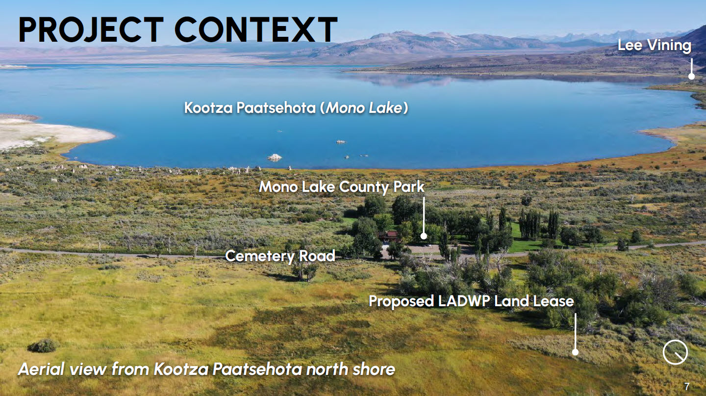
The Kootzaduka’a, the southernmost band of the Numu People (Northern Paiute), have resided in the Mono Lake-Yosemite region since time immemorial. Historically, the Kootzaduka’a (also spelled Kutzadika’a or Kuzedika) lived a hunter-gather lifestyle as they migrated throughout the region following game and harvesting plants at appropriate times. However, beginning in the early 1800s, westward colonization introduced gold mining, cattle ranching, and boomtowns that quickly forced the tribe’s population out of their homeland, with only 83 tribal members remaining today. To conserve, restore, and revitalize its natural and cultural heritage and envision a better future for its native homeland and the Kootzaduka’a people, the tribe has been fighting for federal recognition for the past 150 years. Tribal members seek to establish a sovereign land base within their ancestral homelands in the Eastern Sierra Mona Lake basin by re-acquiring lands stolen from their ancestors with support from governments, nonprofit organizations, academic institutions, and the public.
The Kootzaduka’a tribe has been recognized as a tribal political entity and collaborative partner by federal agencies such as the U.S. Forest Service and National Park Service; state, county, & local governments; and many environmental groups and non-profit organizations. The tribe is currently receiving technical assistance from the National Park Service’s Rivers, Trails, and Conservation Assistance (NPS-RTCA) program. The tribe’s own Indian Community Cultural Preservation Association (a 501 (c) (3) nonprofit organization) has just received $2M+ from the Sierra Nevada Conservancy’s Strategic Land Conservation Directed Grant Program. In partnership with the Eastern Sierra Land Trust (ESLT), the tribe will purchase a 160-acre parcel called Tubbe Nobe near Mono Lake and Lee Vining in Mono County. However, the tribe has not received federal recognition, which is a critical step to fully reclaim lost tribal lands, protect its natural and cultural heritage, and provide healthcare and education to its people. Much effort and support are needed to achieve such a goal.
The tribe aims to develop visionary concepts for a Tribal Heritage Park and Interpretive Trail within their ancestral homelands in the Eastern Sierra. To support such a vision, the tribe first seeks to identify opportunities for co-management and joint stewardship of federal, state, and county lands upon which the Tribal Heritage Park and Interpretive Trail can be located. The US Forest Service, Bureau of Land Management (BLM), and Los Angeles Department of Water and Power (LADWP) are among those agencies which have indicated support for the tribe and with whom potential acquisition, leasing, and co-management of lands are under discussion. These opportunities can not only lead to tribally centered conservation, stewardship, land management, and education but also generate nature-based solutions to climate resilience, recreation, and local economic prosperity for their community. These collective efforts are expected to strengthen further the tribe’s case for re-acquiring lands stolen from their ancestors as a catalyst for sovereignty, self-determination, and federal recognition. As the project’s academic partner, the CPPMLA master project studio will collaborate with the tribe, federal, state, and local agencies, environmental groups & non-profit organizations, and the general public to provide expertise and technical support related to but not limited to background research, mapping of natural and cultural resources of the landscape system, conducting regional and site analyses, identification of opportunities for land acquisition, modeling of multi-benefit land acquisition criteria and priority system for co-management and joint stewardship, and the development of planning visions & design proposals related to the Tribal Heritage Park and Interpretive Trail system. The project team will also think holistically about how the various locations might serve not only the tribe but the greater Eastern Sierra regarding recreation opportunities, education, cultural interpretation, land stewardship & conservation, and economic development.
.
City of Pomona, CA
Walkways of Inclusion: Unveiling Assets and Inequalities in Pomona, California
Chip Erwin, Trinity Gomez, Aliah Mitchell & Abraham Vera
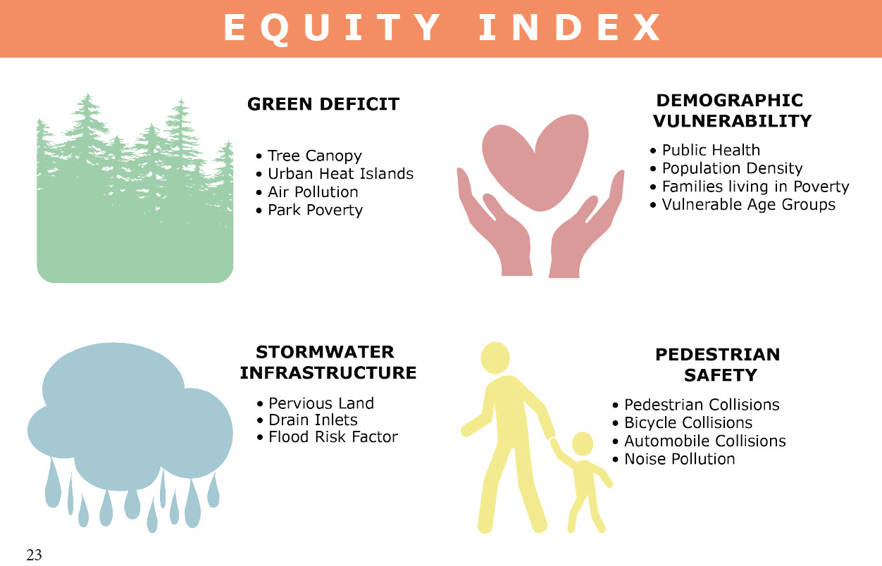
Pomona is a city of approximately 150,000 residents on the edge of Los Angeles County, approximately 25 miles east of downtown Los Angeles, and of course is home to Cal Poly Pomona University. Our studio has partnered with the City and local community-based organizations a number of times in recent years, to explore climate change action, parks and open space advocacy, and environmental justice issues. This year we have an opportunity to continue this partnership to examine the potential for an equity-based approach to the integration of green infrastructure in city streets.
Streets represent the majority of public space in the City of Pomona. The public rights-of-way typically include travel lanes, parking lanes, sidewalks, and surface conveyance of stormwater via curbs and gutters, as well as oftentimes overhead and underground utilities, street trees and parkways, and subsurface stormwater catchment and conveyance. Streets are often excessive in width in comparison to the traffic they experience, and prevalence of assets such as parkways for tree planting, and negative characteristics such as overhead utilities, are not equally distributed throughout the community. In addition, flood hazards impacting streets and adjacent property are not evenly distributed across the city. Often human infrastructure, such as freeway corridors contribute to the patterns of flood risk. The city is interested in addressing inequities inherent in the street infrastructure by examining ways in which green infrastructure and other improvements may be integrated into re-design of public rights-of-way. Work will include the development of an equity-based smart-city model using Geo-AI and machine-learning technologies for prioritizing improvements, as well as policies and design strategies for integrating stormwater treatment, urban forests, and active transportation.
.