Landscape of Wildfire: The Present, Past and Future
Sarah Fisher | May 12, 2021
My personal relationship with wildfire changed forever on Labor Day weekend in 2020, at a family cabin near Shaver Lake in the southern Sierra. It was an unusually hot weekend, so we slept with the windows open, hoping to cool off. I awoke around 2 am to a strong smell of smoke coming from outside. I rose and closed the window.
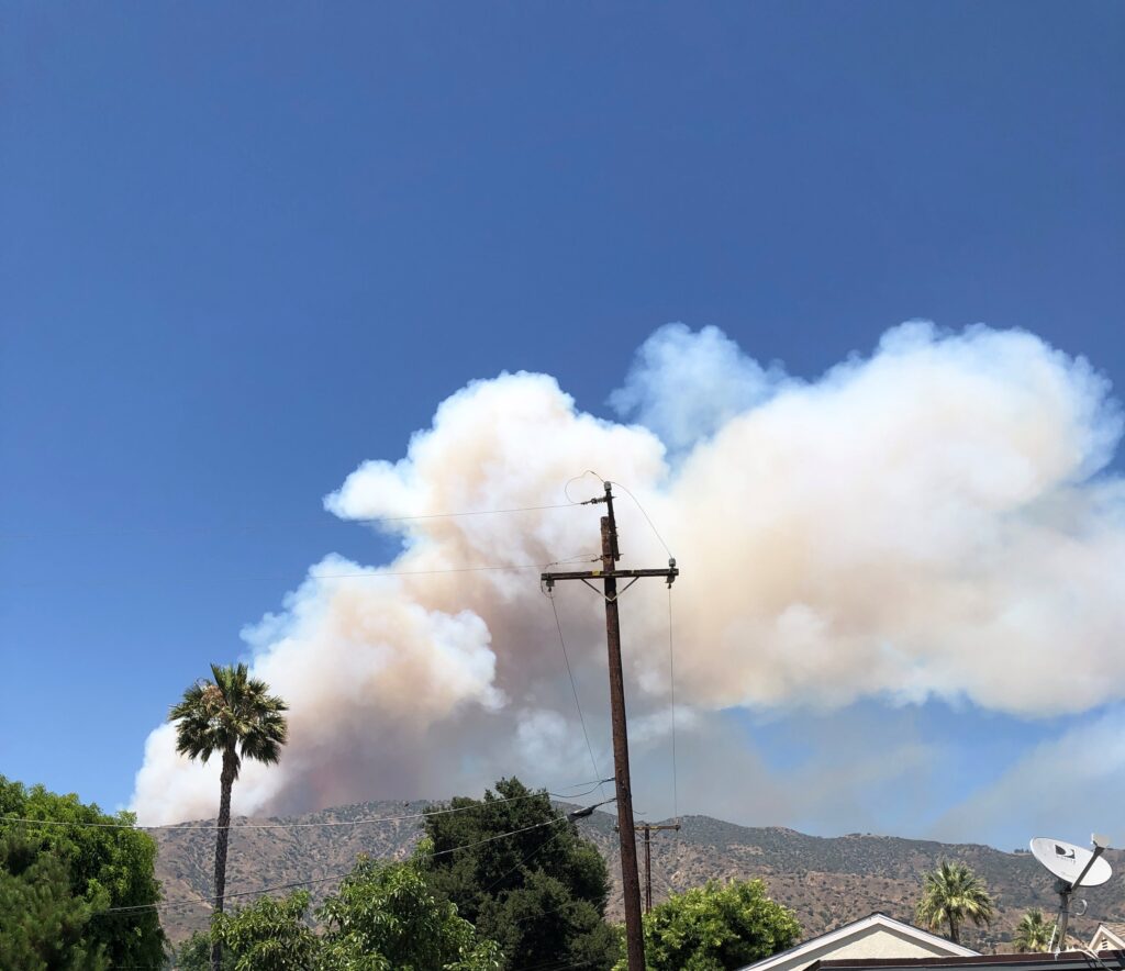
We woke the following morning to news that a fire had started 30 miles away in a canyon higher up in the mountains. There was a plume of smoke, but it was no cause for concern yet, as the fire was quite far away.
That day there was record heat across California. Where we were in the upper elevations of Fresno county, the high was 102°F, up from an average of around 90°F. As the day went on the stifling heat increased, and the smoke got thicker with a strong smell. The sky grew more orange in color. The loud rumble of fire-fighting planes soaring above became more frequent. As we settled in for the evening, evacuation alerts for communities 15 miles away buzzed on our phones. The fire, now known as the Creek Fire, grew rapidly. We left the house and went down the road in the direction of the fire. We saw flames cresting on the next ridge, 2.5 miles away. My family and I prepared for our potential evacuation that night, listening for emergency alerts from our phones and frantically refreshing the CalFire website to see the boundaries of the fire. I fell asleep that night, worried that we would wake up surrounded by flames.
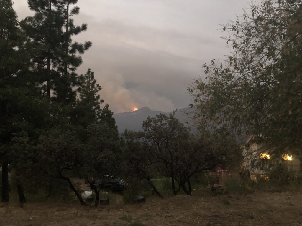
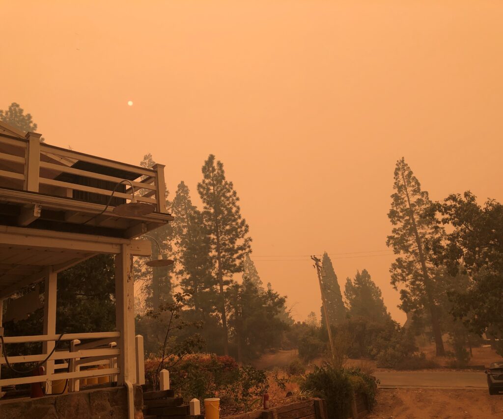
When I woke up the next morning, I knew instantly something was wrong. There was no sound. The forest was eerily silent because birds and other animals had left. The air was so thick with smoke that we could not see the neighbor’s house across the road. In the span of 45 minutes, we grabbed important documents, then nostalgic mementos, and packed our cars up to drive home. Thirty minutes later, as we were driving down the mountain road, the evacuation alert for our area popped up on my phone. I did not feel relief until the sky had changed from orange to blue almost an hour later, driving down highway 99 near Visalia in the Central Valley.
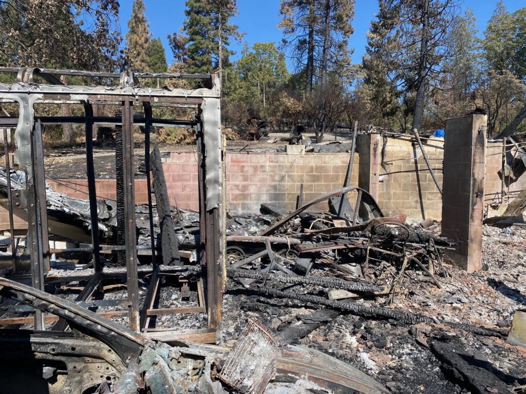
The Creek Fire ravaged the southern Sierra, raging out of control for weeks, burning almost 400,000 acres and forcing 40,000 people to evacuate. The fire reached our neighborhood one day after we evacuated. One quarter of the homes were damaged or destroyed. We were incredibly fortunate that ours was not one of them.
When you live in a rural mountain community in the West, the inherent risk of wildfire is understood. Two years earlier, I sat in the same cabin and watched as a crew of wildland fire-fighters cleared a 20’ wide firebreak line nearby, saddened that they were removing so much native vegetation. The area where they cut the break was a natural meadow, full of birds, deer, and sometimes bears that relied on those plants for shelter and food resources. The firebreak initially symbolized to me the brute force of humans against the natural world, leaving blunt edges, scraped earth and damaged vegetation. But, as the Creek Fire raged, it came to symbolize our last chance against a fire raging out of control.
According to CALFire, as California’s Department of Forestry and Fire Protection is known, in 4,177,856 acres of land in California burned and 10,488 structures were lost to wildfire in 2020 alone. Fire hazard will only increase in significance as the wildland-urban interface increases in size, as climate change alters weather patterns to make fires more likely and as a history of fire suppression in many parts of the west makes fire more severe when they do occur. The decisions we make about our landscapes in relation to fire remain important for the health and prosperity of humans and the landscape.
California’s Fire History
Southern California is a fire-adapted Mediterranean climate, with hot, dry summers and wet, cold winters. Other Mediterranean climates are also adapted to fire regimes, such as those in southern Spain and Australia. After long hot summers, dry brush ignites easily in late summer and early fall. In southern California it is usually the Santa Ana winds blowing hot dry air at high speeds desiccating vegetation and fueling fast moving fires in fall and winter. Evidence has shown that California’s landscape has been burning at intermittent intervals for thousands of years.
The fire regime in southern California changed rapidly after being settled by Europeans. Before their arrival, Indigenous communities used fire as a land management practice to burn down brush and regenerate soil. When the European settlers arrived, they changed the fire management model to one that focused heavily on fire suppression, as the settler’s feared the damage that fires caused. They cleared land and put out fires that started naturally, which prevented the intermittent cycle of fire upon which the local ecology depended.
In a fire prone region like southern California, this history of land mismanagement has significantly altered the frequency and size of the fires that occur, and the effects of climate change are exacerbating the problem. The four largest fires that have been recorded in California occurred between 2018 and 2020. This cycle with more frequent and intense fires reduces the landscape’s ability to recover between events, and allows for fire prone invasive plants, such as cheat grass and mustard, to get established in the seed bank.
Perspectives on Fire
There are a multitude of perspectives about how to manage landscapes in the wildland urban interface to protect people and their property from fire. Vegetation is often the first focal point of attention in fire management scenarios, because it is easy to control and a primary driver of fire.
Local Fire departments, Cal Fire, and the United States Forest Service all regulate the management of vegetation and hardscaping on property in and adjacent to fire-prone forested areas in California. These agencies primarily look at the forests in terms of the amount of vegetation present that can fuel a fire. In high risk areas they cut large fuel breaks, which often remove huge strips of vegetation from previously undisturbed forest ecosystems. While these fuel breaks offer some protection, larger wind-driven events characteristic of recent fires may limit their effectiveness and raise questions about whether their benefits are worth the ecological cost.
In Los Angeles County, property owners are required to create Fuel Modification plans. These plans must be submitted to the county and follow rules about the height, structure, and location of vegetation and structures that are built on a property. The term defensible space is often used to describe ideal conditions to defend the home from wildfire. Often these fire management practices mean eliminating vegetation entirely, leaving only bare ground. These barren landscapes serve no purpose beyond short-term fire protection, but often introduce highly flammable invasive weeds, which must be managed even more intensively over time, than the existing native plants. Furthermore, fire in southern California is often driven by high wind events, meaning that embers, not flames, are the highest risk of causing a fire to ignite. The absence of vegetation (due to vegetation clearing practices) in many of these areas means there is nothing to stop the embers as they fly towards structures.
Officials from the United States Geological Survey have looked at data from recent fires and adjusted their recommendations as a result. Instead of 300 feet of defensible space, they found 50-100 feet was most effective. Any sort of vegetation touching structures is considered high risk but widely-spaced lightly irrigated plants within this defensible space may actually absorb embers and offer increased levels of protection. More importantly, their findings show that building standards are the most important factors in determining risk from fire. These include fire resistant building and hardscape materials, the sealing attics, and the removal of debris from gutters.
All of these recommendations and management practices can improve outcomes, but they are no guarantee. There are some areas that are always going to be high fire risk zones. You can follow every fire measure, but a climate change driven fire roaring through an area will not be stopped by even the most fuel-proof methods. When we design the landscape it is important to consider the locations of the structures we build. Homes built in areas that are in the urban wildland interface are going to always be at risk.
Designing our Future with Fire
Before I was evacuated from the Creek Fire, I felt a sense of security in fire-safe landscape practices, that if you followed the guidelines there would be minimal risk from fire. When we were forced to evacuate our cabin, that sense of security vanished. While the practices mentioned above do make a difference in preventing a home from burning, it was at that moment when I realized that the fires we are going to face in the future are going to be more devastating than the fires we have historically experienced. I also perceived firebreaks to be destructive and mechanisms to introduce invasive plants. But in the instance of this fire, that firebreak may have played an important role in our cabin not burning. This experience has caused me to reconsider my perspective on firebreaks, and contemplate how they can be designed to be effective and less damaging to ecosystems.
In the years ahead we are going to be faced with the reality that there is no single solution to this problem. There are many types of actions we can take to help protect ourselves, like fire proofing our homes, clearing dry invasive brush, and planting native fire adapted plants. Before we can design landscapes to work effectively with fire we have to embrace a mutual relationship. We know the inevitable risks we face from fire, but we also know that fire is part of the forces that shape the wonderfully diverse ecosystem we live in.
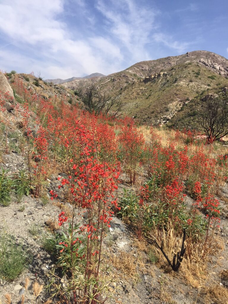
There are almost 100 plants native to California that are reliant on fire to reproduce at some capacity. They create a beauty unique to the ecosystem that cannot be replicated anywhere else in the world. Fire is inevitable, and often unstoppable. We must be ready to adapt and embrace a future with fire, even if we don’t know the best way to do it yet.
The Central Sierra Resiliency fund is a non-profit organization helping revitalize the communities and the forests that were affected by the Creek Fire.

Sarah Fisher is a graduate student in Landscape Architecture at Cal Poly Pomona, set to graduate in 2021. She has a B.S. from Humboldt State University in Wildlife Biology, which informs her passion for ecology focused design. She hopes to create landscapes that support human health in the face of climate change and biodiversity for generations to come.